|
| *****SWAAG_ID***** | 688 |
| Date Entered | 24/02/2013 |
| Updated on | 25/02/2013 |
| Recorded by | Tim Laurie |
| Category | Geographical Record |
| Record Type | Archaeology |
| Site Access | Public Access Land |
| Record Date | 17/02/2013 |
| Location | Grinton |
| Civil Parish | Grinton |
| Brit. National Grid | SE 047 984 |
| Altitude | 200m |
| Geology | Ice dammed lake edge or river terrace |
| Record Name | Linear Earthwork on Harkerside seen beyond Grinton Bridge, Grinton Church and The Bridge Hotel from Fremington Edge. |
| Record Description | This view of the linear earthwork which runs through the pastures beyond Grinton is of interest. |
| Additional Notes | Having looked longingly up to Fremington Edge from the car park of the Bridge Hotel very many times, I thought that a look back to the Bridge Hotel Car park, the linear earthwork, the Church and the Bridge- from Fremington Edge would be appropriate. |
| Image 1 ID | 4037 Click image to enlarge |
| Image 1 Description | Grinton Bridge, the linear earthwork and the Harkerside Pastures from Fremington Edge | 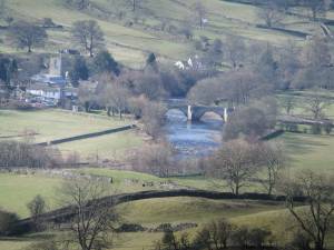 |
